Général
Accueil
Présentation
Aide
Base de données
Espèces
Liste
Photos
sel
Festuca pratensis...
Rechercher
Habitats
Données géographiques
Liste
sel
Festuca pratensis...
sel
Plat des Etançons
Rechercher
Filtres
Collections / Herbiers
Liste / Rechercher
Autres
Checklists
Législation / Listes rouges
Divers
BIOGEOnet carto
Conversion de coordonnées
Lexique
Statistiques
Emmanuël Sérusiaux
log
pwd
Données GBIF
Galerie photo
Retour
Station
Observations
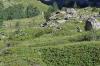
Station : Plat des Etançons
Informations sur la station
Nom de la station
Plat des Etançons
Localité
La Bérarde
Pays
France
Région
Rhone-Alpes
Latitude (WGS 84)
44°56'31.7557''
Longitude (WGS 84)
6°17'55.6074''
Projection d'origine
WGS84
MGRS (WGS 84)
32TKQ8688880074
Altitude
1900m
Zone
1km²
Confidentialité
Publique
Groupe de travail
Données privées
Encodeur
Claude DOPAGNE, le 01-11-2012
Modification
Claude DOPAGNE, le 01-11-2012
Localisation
Fond de carte :
Carto Positron (retina)
Carto PositronNoLabels (retina)
CGMW Bedrock and Structural geology - Eurasia
CGMW Bedrock and Structural geology - World
Esri World Gray Base
Esri World Imagery (10000km - 30m)
Esri World Imagery (Clarity)
Esri World Street Map (10000km - 50m)
Esri World Topo Map (10000km - 50m)
GBIF OSM-Bright (retina)
General Bathymetric Chart of the Oceans
Google plan
Google satellite
Google Satellite Hybrid
Google terrain
HERE Hires Normal Day Tile
HERE Hybrid Map Tile
HERE Terrain Map Tile
MapTiler Basic (vector)
MapTiler Bright (vector)
MapTiler Pastel (vector)
MapTiler Topo (vector)
MapTiler Topographique (vector)
MapTiler Voyager (vector)
mundialis Topographic OSM WMS
mundialis Topographic OSM WMS (basic)
NASAGIBS Earth At Night 2012 (5000 - 30 km)
National Geographic Map (10000km - 2 km)
Natural Earth II (10000km - 100km)
OpenTopoMap (50km - 300m)
OSM (10000km - 30m)
OSM BERGFEX (retina)
OSM CyclOSM
OSM HD (retina)
OSM Hot (10000km - 30m)
Thunderforest Landscape (retina)
Thunderforest Mobile-Atlas
Thunderforest OpenCycleMap (retina)
Thunderforest Outdoors (retina)
Thunderforest Transport (retina)
WAZE
Wikimedia Maps (retina)
World Navigation Charts
Worldwide Public Transport
WWF - Terrestrial Biomes 2007
CartoWeb-TOPO (300km - 30m)
CyclOSM Belgique
IGN - Topo gris
OrthoPhotos Belgium
Carte bioclimatique - essences forestières
Cartes de Vandermaelen (1846-1854)
Climax (100km - 300m)
Ferraris 1777
Modèle Numérique de surface (2013-2014)
Modèle Numérique de Terrain (MNT) (ERRUISSOL)
Modèle Numérique des Pentes (2013-2014)
Occupation du sol COSW 2 07 (30km - 50m)
Occupation du sol en Wallonie - WALOUS 2019 IA
OrthoPhotos 1971
OrthoPhotos 1994-2000
OrthoPhotos 2009-2010
OrthoPhotos 2012-2013
Orthophotos 2012-2013 Infrarouge
OrthoPhotos 2015
OrthoPhotos 2016
Orthophotos 2017 (carte partielle)
OrthoPhotos 2018
OrthoPhotos 2019
OrthoPhotos 2020
OrthoPhotos Last
Principaux Types de Sols
Relief (vue simple) - MNS 2013-2014
Réseau écologique MAE9 (100km - 300m)
Utilisation du Sol en Wallonie - WALOUS 2018
Valeurs écologiques (100km - 300m)
Zones agro-géographiques
Bruxelles
Basiskaart Vlaanderen (GRB)
Bebossing op de Ferrariskaarten
GRB-Basiskaart
MAES Flanders ecosystem services - Pollination
MAES Flanders ecosystem services - regulation erosion
Potentieel natuurlijke vegetatie
Annual Temperature Change 2021-2050
Background (500km - 2km)
Bergfex OSM (retina)
Corine Land Cover (2012)
CyclOSM
Ecosystem (EUNIS level 1 2006 v 2 1)
Ecosystem (EUNIS level 2 2006 v 2 1)
Ecosystem Type Map v3.1
EUNIS Ecosystems (2017)
GISEurope Bedrock and Structural geology
Maps.Refuges.Info
MTB map (mountain biking and hiking) (3km - 30m)
Natural river basins of Europe
Pollution lumineuse 2018 (1000 - 3 km)
Cartes géologiques
IGN
Lithologie simplifiée
OSM France
MapTiler NL Cartiqo Topo (vector)
NL PDOK TOPraster
Nordrhein-Westfalen (100km - 30m)
Outdooractive summer
Cadastre
Carte de base haute résolution
Carte topographique automatique
Hybride
Orthophoto (dernier)
Zones protégées d'intérêt national (ZPIN)
Geoland Basemap (retina)
Geoland Basemap Orthofoto
IGN España (5000km - 30m)
Imagen SPOT 5 (5000km - 30m)
Primera edición MTN50
Historical maps from 1919-47
MapTiler UK OS Open Zoomstack Outdoor (vector)
MapTiler UK OS Open Zoomstack Road (vector)
Carte nationale
OSM Suisse
Kartverket N50 topo
North America Elevation Background (500km - 30m)
Topo map USA + Hawaii (not Alaska)
TopOSM - Relief (1000km - 500m)
USGS Hydro NHD (10km - 300m)
USGS TNM Imagery Topographic
USGS Topo Base Map (5000km - 300m)
USGS_EROS_Ortho_SCALE (2km - 30m)
Ecosystems
test
Superposition :
Notice
: Undefined index: cat2 in
/var/web/biogeone/public_html/old/php/fiche_st_2.php
on line
729
Aucune
Carto PositronOnlyLabels (retina)
Esri Boundaries + labels (10000km - 30m)
Esri World Hillshade (10000km - 300m)
Esri World Terrain Base Map (10000km - 10km)
Esri World Transportation (1000km - 30m)
General Bathymetric Chart of the Oceans
Global Forest Cover Loss 20002016
Google Traffic
Graticule
HERE Street tile Day Tile (5000km - 30m)
Labels
Last of the Wild Project, V 2 (2005)
MapTiler Positron (vector)
MapTiler Relief (10km) (vector)
MapTiler Roads (vector)
MapTiler Streets (vector)
OpenRailwayMap Max (retina)
OpenSeaMap (20km - 30m)
RAMSAR Sites
Urban Rural Extents in the 10m Low Elevation Zone
Waymarked Trails: Cycling
WCMC World Database of Protected Areas 2014
Wildareas: Human Influence Index v2
World Database on Protected Areas
CartoWeb-CROSSBORDER (300 - 2 km)
CartoWeb-OVERLAY (500m - 30m)
Courbes de niveau
Grille IFBL
Parcellaire cadastral (100m - 30m)
Trafic (ralentissements)
Aléa d'inondation en vigueur (- 100m)
Arbres et haies remarquables (500m - 30m)
Atlas du karst wallon
Axes de ruissellement concentré (LIDAXES)
Bassins versants (Secteurs PARIS version 2016 - 2021)
Bassins versants ORI (version 2)
Bords de route (300m - 30m)
Carte géologique (2012) (500km - 300m)
Carte Numérique des Sols (300m - 100m)
Cartographie des zones inondées - juillet 2021 (10km-)
Circulation des poissons (3km - 100m)
Climax (100km - 300m)
Conservation de la Nature (3km - 300m - 30m)
Contrats de rivière
Dénominations géographiques en Wallonie
Etat des Sols (BDES) (500m - 30m)
Filaire des voiries régionales (10km - 30m)
GR Wallon
Liaisons écologiques (CoDT)
Limites des contrats de rivière
Masque forestier
Masses d'eau de surface (MESU)
Modèle Numérique de Terrain (MNT) (ERRUISSOL)
Natura 2000 (2017) (1000km - 30m)
Offres touristiques en Wallonie
Parcellaire agricole anonyme 2016 (300m - 30m)
Parcellaire agricole anonyme 2016 - cultures
Parcellaire agricole anonyme 2017 (300m - 30m)
Parcellaire agricole anonyme 2020
Parcellaire agricole anonyme Last
PASH (SPGE) (3km-30m)
Périmètres de contraintes karstiques (10km - 30m)
Peste porcine africaine (2018)
PICC (nouveau) (10km - 100m - 30m)
Plan de secteur - projets de modification (500m - 30m)
Plan de secteur en vigueur (2km - 100m)
Portance écologique prairies maigres sur calcaire (100km - 100m)
RAVeL et Véloroutes (30km - 30m)
Réseau écologique MAE9 (100km - 300m)
Réseau hydrographique wallon (RHW SIMPLE)
Réseau hydrographique wallon (RHW)
Réseau routier régional (10km - 30m)
Services écosystémiques (SES)
Terrils 2018
Valeurs écologiques (100km - 300m)
Zone de présence permanente (ZPP) du loup
Zones de prévention des captages (2km - 30m)
Itinéraires cyclables régionaux
Biolog. Waarderingskaart (BWK1) Zones (2km - 30m)
Biolog. Waarderingskaart (BWK2) Habitat (2km - 30m)
Biolog. Waarderingskaart (BWK2) Zones (2km - 30m)
GRB - WTZ - watergang (1km - 30m)
GRB-Basiskaart
Annual Temperature Change 2021-2050
Biogeographical Regions 2011
CyclOSM
Ecosystem Type Map v3.1
Forest Cover 2012
Greenness - End of vegetation period
Greenness - Length of the peak period
Greenness - Start of vegetation period
Life EU
Natura 2000
Natura 2000 (2016)
Pollution lumineuse 2018 (1000 - 3 km)
Protected Sites (CDDA_Dyna_WM) (5000km - 30m)
Natura 2000 SIC et ZPS
Parcs nationaux et régionaux
Réserves naturelles et réserves intégrales
Sites d'importance communautaire JOUE (ZSC,SIC)
Sites Ramsar
Zones de protection speciale
NATURA 2000 - ZAC - Habitats Directive
NATURA 2000 - ZPA - Birds
Réserves forestières
Secteurs écologiques
Geoland Basemap Overlay
Parcs suisses (zonage)
Ramsar
REN zones agricoles extensives
REN zones aquatiques
REN zones de forêts
REN zones de prairies sèches
REN zones humides
Réserves d'oiseaux d'eau
Réserves forestières
Réserves forestières Pro Natura
Sites de protection de la faune
TopOSM - Contours (2km - 500m)
TopOSM - Features (1000km - 500m)
Ecoregiones (200km - 50km)
Ecosistemas (30km - 50m)
Ecosistemas Andino
Forest Canopy Height
Hidrographia
Land Use/Cover
Cartografía Básica escala 1:100.000
Prioridad de Conservación (20 km - 50m)
Registro Unico Nacional AP (300km - 50m)
Sistema Nacional de Área Protegidas (200km - 50m)
Zonificación 2011-2017 (500km - 50m)
Malaria transmission globally - Plasmodium falciparum (2010)
Malaria transmission globally - Plasmodium vivax (2010)
Localisation
Encodeur(s)
Claude DOPAGNE
Permalink
: