|
Informations on the station |
|
|
|
| Name of the station |
4180/118 | |
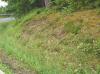
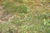
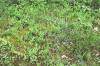
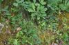
| Locality |
Trois-Ponts - Trois-Ponts |
| Local name |
Manonfat |
| Country |
Belgium |
| Area |
Province de Liège |
|
| Latitude (WGS 84) |
50°22'24.1708'' | |
| Longitude (WGS 84) |
5°52'30.4876'' | |
| X (BE LB72) |
257149.726 | |
| Y (BE LB72) |
119138.654 | |
| Coordinates of origin |
BE LB72 |
| IFBL |
G75844 |
| MGRS (WGS 84) |
31UGR0443684098 |
| Altitude |
317m |
| Area |
1km² |
| Surface |
9m² |
|
| Description |
Laande s/ Pinus sylvestris & Quercus robur |
| Confidentiality |
Public |
| Associated workgroup | Bords de routes (Routes) |
| Associated workgroup | Bords de routes communaux (Routes communales) |
| Encoder |
Luc BAILLY, the 11-08-2025 |
| Modificateur autorisé |
Claude DOPAGNE |
| Modificateur autorisé |
François NAVEAU |
| Modification |
Luc BAILLY, the 11-08-2025 |
|
|
|