|
Informations on the station |
|
|
|
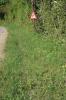
| Name of the station |
6990/121 | |
| Locality |
Hotton - Hotton |
| Local name |
environs du cimetière militaire |
| Country |
Belgium |
| Area |
Province de Luxembourg |
|
| Latitude (WGS 84) |
50°15'40.7259'' | |
| Longitude (WGS 84) |
5°26'54.8902'' | |
| X (BE LB72) |
226992.959 | |
| Y (BE LB72) |
106145.842 | |
| Coordinates of origin |
BE LB72 |
| IFBL |
H74112 |
| MGRS (WGS 84) |
31UFR7451970553 |
| Altitude |
224m |
| Area |
1km² |
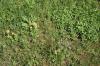
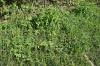
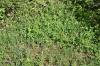
| Surface |
9m² |
|
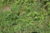
| Description |
Lisière de chênaie-charmaie callcicole |
| Confidentiality |
Public |
| Associated workgroup | Bords de routes (Routes) |
| Associated workgroup | Bords de routes communaux (Routes communales) |
| Encoder |
Luc BAILLY, the 04-09-2025 |
| Modificateur autorisé |
Claude DOPAGNE |
| Modificateur autorisé |
François NAVEAU |
| Modification |
Luc BAILLY, the 04-09-2025 |
|
|
|